If visualised properly, maps can portray complex information in a way that the human brain can process and understand in seconds. That is why we produce maps to depict geostrategic developments and phenomena, especially from a British vantage point. Our geostrategic maps – comprising our GeoAtlas – can be found below:

The Red Sea: The Atlantic-Pacific link
A map depicting the importance of the Red Sea to British interests in the Euro-Atlantic and Indo-Pacific

Chinese encroachments towards Taiwan (August 2022-2023)
A map depicting Beijing’s grey zone military maneuvers towards Taiwan from August 2022

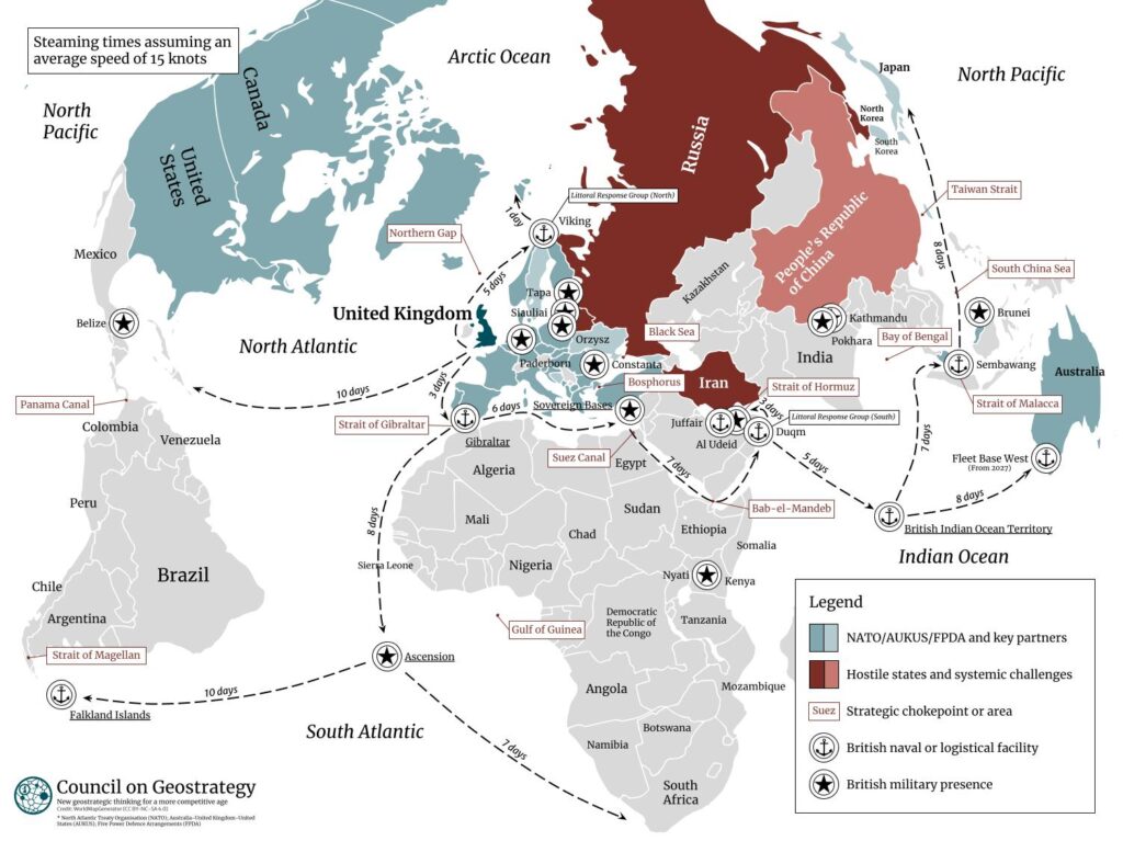
The Royal Navy’s global reach
A map of the global reach of the Royal Navy that visualises the maritime mobility and versatility of British power

A Sinocentric world: The Belt and Road Initiative
A map of the People’s Republic of China’s attempt to centre itself in the global economy through the Belt and Road Initiative

The ‘refresh’ of the Integrated Review
A map of the geography of British power after the ‘refresh’ of the Integrated Review, published by His Majesty’s Government in March 2023

Underwater cables in the Euro-Atlantic region
A map of undersea cable infrastructure in the Euro-Atlantic region, depicting the centrality of the British Isles

The Chinese perspective of the Pacific region
A map of the People’s Republic of China’s geostrategic perspective, including the three ‘island chains’ Chinese geostrategists see as central to expansion

The geopolitics of the Himalayas
A map of the geopolitics of the Himalayas, including Chinese advances along the border with India and ‘stealth annexations’ of Bhutanese territory

The view from China
A map of the view from the People’s Republic of China, depicting the tremendous hurdles Chinese geostrategists must overcome to dominate the Pacific Ocean

The United Kingdom’s centrality to the defence of Europe
A map of the United Kingdom’s central role in the defence of the European continent, showing the focal points of British influence in the 2020s

The trilateral of Poland, Ukraine and the United Kingdom
A map of the trilateral initiative of Poland, Ukraine and the United Kingdom, showing how three-way cooperation enhances European security

The geopolitics of AUKUS
A map of AUKUS, showing how the unique security partnership between Australia, the United Kingdom and the United States encircles Eurasia